
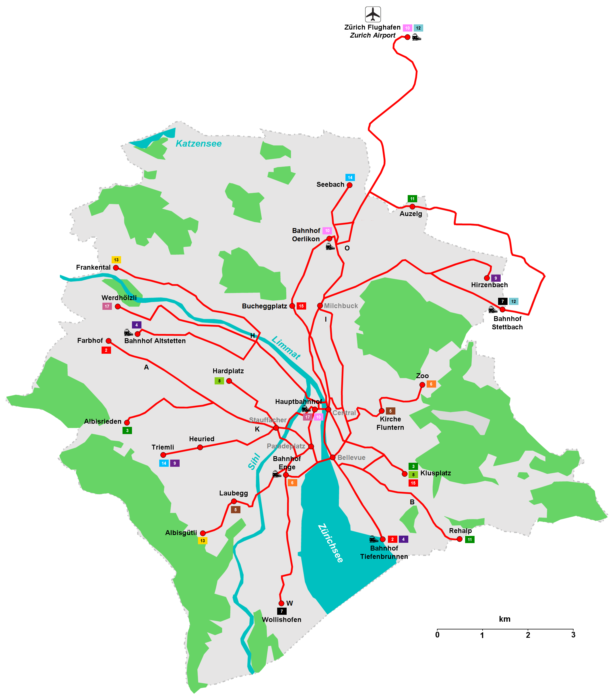
Plik:Tramnetz-zuerich2.png
Rozmiar pierwotny (2140 × 2440 pikseli, rozmiar pliku: 557 KB, typ MIME: image/png)
Opis
| Opis |
Deutsch: Das Tramnetz von Zürich
Français : Le Réseau de Tramway de Zurich
Italiano: La Rete tranviaria di Zurigo
English: The Tramway Network of Zurich
Linien / Lignes / Linee / Lines (2013):
|
||||||||||||||
| Data | 4.3.2007 | ||||||||||||||
| Źródło | Praca własna | ||||||||||||||
| Autor | mrnett1974 | ||||||||||||||
| Inne wersje |
Prace pochodne od tego pliku: Trolley-zuerich.png
|

Licencja
| Ja, właściciel praw autorskich do tej pracy, udostępniam ją jako własność publiczną. Dotyczy to całego świata. W niektórych krajach może nie być to prawnie możliwe, jeśli tak, to: Zapewniam każdemu prawo do użycia tej pracy w dowolnym celu, bez żadnych ograniczeń, chyba że te ograniczenia są wymagane przez prawo. |
Historia pliku
Kliknij na datę/czas, aby zobaczyć, jak plik wyglądał w tym czasie.
| Data i czas | Miniatura | Wymiary | Użytkownik | Opis | |
|---|---|---|---|---|---|
| aktualny | 07:30, 1 lut 2013 | | 2140 × 2440 (557 KB) | Lord Alpha | EN: Schaffhauserplatz - Hauptbahnhof added / Depots added / Captions "Bucheggplatz" and "Bhf Oerlikon" moved DE: Schaffhauserplatz - Hauptbahnhof hinzugefügt / Depots hinzugefügt / Beschriftungen "Bucheggplatz" und "Bhf Oerlikon" verschoben |
| 02:09, 1 lut 2013 |  | 2140 × 2440 (554 KB) | Lord Alpha | Bildgrösse korrigiert / Linienfarben angepasst | |
| 02:07, 1 lut 2013 |  | 2560 × 2440 (575 KB) | Lord Alpha | Reverted to version as of 22:52, 31 January 2013 | |
| 02:00, 1 lut 2013 |  | 2140 × 2440 (554 KB) | Lord Alpha | Bildgrösse korrigiert / Linienfarben angepasst | |
| 00:52, 1 lut 2013 |  | 2560 × 2440 (575 KB) | Lord Alpha | EN: Glattalbahn between Auzelg and Stettbach added (Line 12) / Route of Glattalbahn between Auzelg and Glattpark corrected (Line 11 & 12) / Line 17 (Hauptbahnhof - Werdhölzli) added / Caption "Stauffacher" moved / Caption "Paradeplatz" added DE: Glat... | |
| 18:38, 16 kwi 2011 |  | 2140 × 2440 (476 KB) | DorianCrede | Tramlinie zu Zürich Flughafen hinzugefügt Tramlinie Zürich-West hinzugefügt | |
| 22:45, 11 sie 2008 |  | 2100 × 2100 (442 KB) | Dodo von den Bergen | == Beschreibung == {{Information |Description= Tramnetz von Zürich (Tramnetwork of Zurich) |Source= own work |Date= 4.3.2007 |Author= mrnett1974 }} == Licensing == {{PD-self}} Category:Public transport maps of Zürich [[Category:Rail transport maps | |
| 14:27, 6 mar 2007 |  | 2100 × 2100 (450 KB) | DorianCrede | {{Information |Description= Tramnetz von Zürich |Source= own work |Date= 6.3.2007 |Author= mrnett1974 |other_versions= Tramnetz-zuerich1a.png, Tramnetz-zuerich1b.png }} | |
| 20:42, 4 mar 2007 |  | 2112 × 1996 (388 KB) | DorianCrede | {{Information |Description= Tramnetz von Zürich (Tramnetwork of Zurich) |Source= own work |Date= 4.3.2007 |Author= mrnett1974 }} |
Lokalne wykorzystanie pliku
Poniższa strona korzysta z tego pliku:
Globalne wykorzystanie pliku
Ten plik jest wykorzystywany także w innych projektach wiki:
- Wykorzystanie na de.wikivoyage.org
- Wykorzystanie na eo.wikipedia.org
- Wykorzystanie na eo.wikivoyage.org
- Wykorzystanie na fr.wikipedia.org
- Wykorzystanie na he.wikivoyage.org
- Wykorzystanie na it.wikivoyage.org
- Wykorzystanie na ja.wikipedia.org
- Wykorzystanie na la.wikipedia.org
- Wykorzystanie na ru.wikipedia.org
- Wykorzystanie na scn.wikipedia.org